What is the Lake Superior Water Trail? And Other Q&As
For Starters…
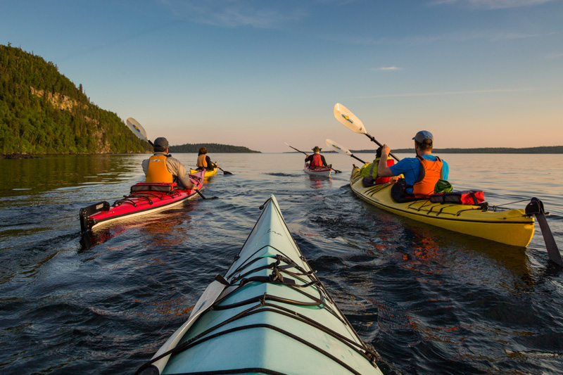
What is a water trail? A water trail is a navigable trail along a body of water such as a river, lake, or coastline that is used for recreational purposes such as kayaking, canoeing, or sailing. A water trail is also called a waterway, a blue highway, or a blueway.
What’s the Lake Superior Water Trail?
The Lake Superior Water Trail (LSWT) is a 1000 km (600 mile) water trail along the Canadian coastline of Lake Superior between Gros Cap Marina Park on Whitefish Bay and Lorne Allard Fisherman’s Park in Thunder Bay. The water trail is a significant link in the Great Trail by Trans Canada Trail, a 24 000 km (15 000 mile) trail system from ocean to ocean to ocean.

How is the Lake Superior Watershed Conservancy involved?
The Lake Superior Watershed Conservancy (LSWC) are the stewards of the LSWT. Working with Trans Canada Trail and Trans Canada Trail Ontario, the LSWC brought together several coastal municipalities, First Nation communities, Ontario Parks, National Parks and Canadian Lighthouses of Lake Superior to create the main access points to the water trail.
One LSWC goal is to connect the many wonderful water trails around Lake Superior to create an international Lake Superior Water Trail encircling the entire lake.
Why Make a Water Trail?
The LSWT is an ancient water route. For thousands of years, long before there was a Highway 17 to road trip along, people have been paddling this coastal trail as part of their way of life. Lake Superior inhabitants were closely connected to the lake. This trail was how they traveled, conducted trade, and explored.
The LSWC’s vision of the future is a healthy Lake Superior watershed sustained through basin-wide initiatives for future generations. Our mission is to protect the Lake Superior freshwater ecosystem for future generations. With the use and promotion of the LSWT, we believe it will inspire individuals and communities to create initiatives that will protect and preserve Lake Superior.
The LSWC is currently working on other projects such as the Big Canoe Project to promote business models to further eco and cultural tourism. We believe that by connecting the health of Lake Superior to the local economy, we can ensure its protection for future generations.

How do I get on the Trail?
There are 16 main access points along the LSWT.
- Gros Cap Marina Park
- Batchawana Bay Provincial Park
- Katherine Cove, Lake Superior Provincial Park
- Michipicoten River
- Hattie Cove, Pukaskwa National Park
- Heron Bay North, Biigtigong Nishnaabeg
- Marathon Boat Launch
- Carden Cove
- Terrace Beach
- Schreiber Beach
- Rossport Wardrope Park
- Red Rock Marina
- Nipigon Boat Launch
- Porphyry Island Lighthouse
- Number 10 Island Lighthouse
- Lorne Allard Fisherman Park, Thunder Bay
But don’t just grab any kayak and start paddling! Never take on paddling a segment of the LSWT without the proper knowledge and equipment.
The following is a checklist from Lake Superior Magazine; at a glance, to paddle any segment of the LSWT you will need:
Lake Superior worthy watercraft such as:
- Sea Kayak with sealed bulkheads at either end and a sea skirt (14ft long or longer)
- Lifejacket (Wear it!)
- Wetsuit or drysuit
- Spare or collapsible backup paddle
- Paddle float and leash
- Whistle
- Bilge pump
- Headlamp
- Compass
- Marine radio
- Waterproof personal locator beacon
- Outdoor basics: water, snacks, bug spray, hat, sunglasses, sunscreen, reflective device
To learn more about safety on Lake Superior visit the following the links:
-
Ontario Sea Kayak Centre
OSKC is one of Canada’s leading sea kayak schools. -
Superior Outfitters (Rossport)
Superior Outfitters offers a wide range of sea kayaking tours and instructional programs suitable for every age and ability level. -
Naturally Superior Adventures (Wawa)
Naturally Superior Adventures offers certified paddling instruction and guided trips on Superior by Sea Kayak and 36 ft Voyageur Canoe. -
Kayaking Safely on Lake Superior: What You Need to Know
Read the full Lake Superior Magazine article that contains the safety checklist. -
A Beginner’s Guide to Kayaking in Michigan
An article from Pure Michigan
Are there amenities available at the LSWT Access Points?
Each of the access points has a different mix of amenities. Currently, some places such as the LSWT Heron Bay North Access Point only has an information kiosk, whereas, the LSWT Gros Cap Marina Park Access Point has an EZ Dock, a Clivus Multrum composting toilet, picnic tables, secure canoe & kayak locker and bear-proof garbage and recycling containers. The LSWC is continuing to improve upon the amenities available at each access point to further enhance the experience of using the trail in a way that is accessible and inclusive for everyone.
The Full List of Water Trail Access Features (Not every site has every feature):
-
Universal Access site plans designed by Cynthia Burkhour of Access Recreation Group for 15 priority Lake Superior Water Trail access locations with the goal being each site will be compliant under the AODA (Accessibility for Ontarians with Disabilities) Act by July 1, 2020.
-
High-quality Water Trail Access Point amenities include universal access EZ Docks, Clivus Multrum composting toilets, bear-proof garbage and recycling containers, universal access picnic tables, and dog waste disposal stations.
-
Additional Land Trail connections to Aguasabon Gorge, Red Rock Mountain and the Nipigon River Overlooks enhance the Lake Superior water trail user’s experience.
-
Kiosks at each access point display safety information, photos and maps connecting the Lake Superior Water Trail to local hiking trails, parks, B&Bs, food services, and local cultural attractions and other services in nearby communities and businesses.
See you on the trail!
Author Bio:
Holly Drew is a professional writer from Sault Ste. Marie, Ontario, where she has spent a lot of time hiking in the beautiful Algoma District and Upper U.P., Michigan. Holly’s other home is in Lima, Peru, where she lived for one year as a Rotary International Exchange Student. Holly also volunteers as a Communications and Events Coordinator for Youth Odena, a by-youth-for-youth advocacy group in Sault, Ontario.